2024 · Case study
OSM Business Locator
A Python CLI that turns a search polygon into a planner-ready business inventory from OpenStreetMap — Excel, GIS files, and an interactive Leaflet map.
Results are derived from OpenStreetMap and are licensed under ODbL. The inventory is only as complete as OSM tagging; it is not a licensed business registry. Local filesystem paths from the original machine are not published here.
Executive Summary
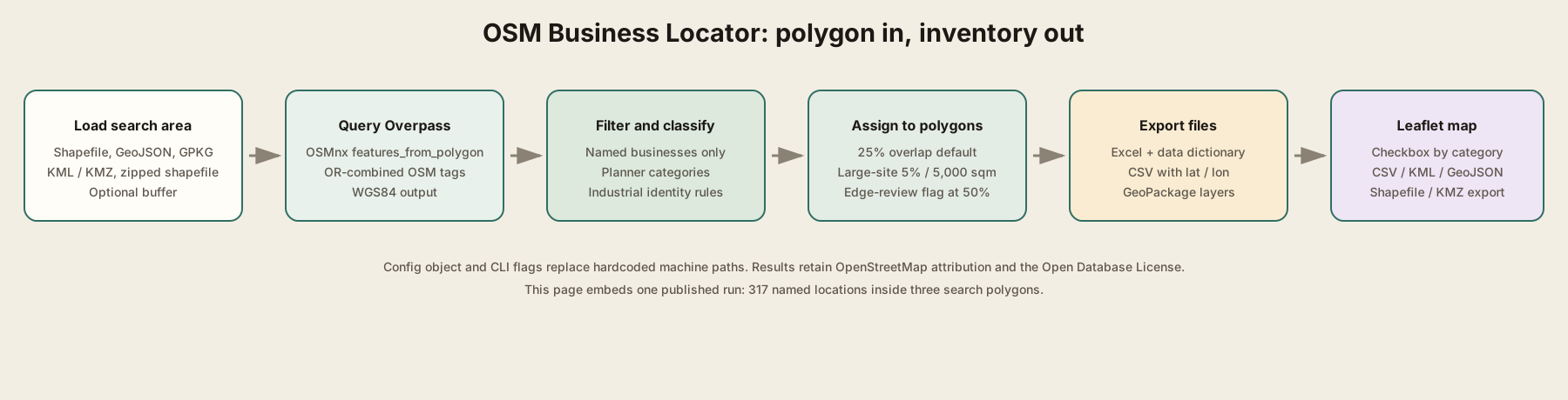
A study area is often already sitting in a shapefile, GeoJSON, or KML. The missing piece is a current list of shops, offices, schools, clinics, and named industrial sites inside it — something a planner can open in Excel or drop into GIS without another ad-hoc Overpass notebook. OSM Business Locator takes that polygon, queries OpenStreetMap, keeps named in-scope destinations, maps raw tags onto planner categories, and assigns each feature to a boundary using overlap thresholds rather than a careless centroid. Outputs are an Excel workbook with summaries and a data dictionary, GIS-ready CSVs, a GeoPackage, and the Leaflet map embedded below. The earlier single-notebook workflow is now an installable CLI whose settings live in a config object, so machine-specific paths are not baked into the code. This page shows one run against a set of service-area polygons.
- Problem
- Planners needed a repeatable way to inventory businesses and destinations inside a study polygon without paying for a proprietary registry or redrawing the same Overpass pull by hand.
- Who
- Service planning, GIS, and anyone who needs a first-cut land-use inventory inside a boundary.
- Solution
- A config-driven Python package queries Overpass via OSMnx, filters and classifies named OSM features, assigns them to polygons with explicit overlap rules, and writes Excel, CSV, GeoPackage, and a Leaflet map.
- Outcome
- One published run returned 317 named locations across 15 planner categories, including 16 industrial employment centers, with OSM attribution retained on every record.
Business Problem
Background
Proprietary business lists are expensive, incomplete in their own ways, and often lag. OpenStreetMap is public, spatially explicit, and already used in planning work — but a raw Overpass dump is not an inventory. Tags are inconsistent, industrial buildings are often unnamed sheds, large parcels only nick a study area, and the people who need the file still want Excel plus a map. The job was to turn a boundary layer into those deliverables without leaving hardcoded local paths in the pipeline.
Challenges
- OSM tags do not map one-to-one onto planner language (shop=yes vs. a grocery, amenity=fuel vs. automotive)
- Industrial landuse and warehouse buildings are noisy unless a real employer/site name is present
- A large plant can sit mostly outside a study polygon and still matter if enough of the site is inside
- Multipart boundaries and overlapping service areas need explicit assignment rules, not a silent centroid
- The original notebook hardcoded machine-specific paths; the rewrite had to be rerunnable as a CLI
Stakeholders
- Service planning and land-use staff who need a first-cut inventory inside a study area
- GIS users who want points, original geometries, and the search polygon in one GeoPackage
- Analysts who will open Excel, filter by category, and export a subset from the map
Success criteria
- One command from a polygon file to Excel, CSV, GeoPackage, and an interactive map
- Planner categories instead of raw OSM keys in the delivered inventory
- Documented overlap rules, edge-review flags, and duplicate flags rather than silent drops
- OpenStreetMap attribution and ODbL license carried on every exported record
Solution Architecture
Data sources
- Caller-supplied boundary layer (shapefile, GeoJSON, GeoPackage, KML/KMZ, or zipped shapefile)
- OpenStreetMap features intersecting the search polygon, via the Overpass API through OSMnx
Stack
Design decisions
Why OpenStreetMap instead of a paid registry? OSM is public, spatially explicit, and redistributable under ODbL with attribution. Completeness follows tagging, which the disclaimer states; the pipeline does not pretend to be a licensed business list.
Why a package and CLI instead of a notebook? The notebook worked once on one machine. A PipelineConfig dataclass and osm-business-locator console script make every overlap rule, tag filter, and output flag an argument, so paths and defaults are not hardcoded.
Why overlap rules instead of centroids? Industrial parcels and campus polygons are large. A centroid can miss the study area even when thousands of square meters sit inside it. The default keeps a feature at 25% overlap, or at 5% if at least 5,000 m² overlap, and flags edge cases below 50% for review.
Data Modeling
Business metrics
- Location count
- Named in-scope OSM features after tag filters; unnamed points are dropped unless the include-unnamed flag is set.
- Overlap percent / area
- Share and square meters of a polygonal OSM feature that sit inside the assigned boundary, used for the 25% / large-site / edge-review rules.
- Industrial employment center
- Named industrial, warehouse, works, or logistics sites that pass the industrial-identity filter — 16 in this run, also written to a breakout CSV and worksheet.
Governance
- Every row carries Source = OpenStreetMap contributors and License = Open Database License (ODbL)
- Query_Date_UTC stamps the Overpass pull on every exported row
- Potential_Duplicate flags same-name records at the same rounded coordinate instead of deleting them
- Boundary_Edge_Review flags assignments with overlap below 50% (3 records in this run)
How the inventory is structured
These are the rules that turn OSM tags into a planner-ready table, not a statistical model.
Planner categories, not raw tags. shop, amenity, office, healthcare, tourism, and industrial keys are mapped onto Food and Beverage, Retail, Education, Industrial Employment Center, and the rest so a non-GIS user can filter the workbook.
Named industrial sites only. Generic labels such as Building or Warehouse are not treated as employers. A plant enters the inventory when a name, brand, operator, or owner is present.
Assignment is a rule, not a centroid. Points must sit in the polygon. Areas need 25% overlap, or 5% with at least 5,000 m² for large sites. Weak overlaps stay in the file with an edge-review flag.
Provenance travels with the row. OSM URL, element id, query timestamp, source, and license columns mean the Excel file can be redistributed without losing attribution.
Pipeline & Engineering
Ingestion
- Read the caller’s boundary file with whichever GDAL/OGR drivers are available
- Optionally buffer, split multipart parts, and prompt for a boundary-id field when several candidates exist
- Query Overpass through OSMnx features_from_polygon using OR-combined default tags (shop, office, amenity, industrial, and related keys)
Transformations
- Drop inactive and out-of-scope tags; keep named businesses, amenities, and industrial sites with a real identity
- Classify into planner categories and subcategories; assemble address, phone, website, and brand from OSM fields
- Build a representative point inside polygonal geometries; assign to boundaries with overlap and large-site rules
- Flag potential duplicates and edge-review records without deleting them
Automation
- Installable osm-business-locator console script; every former notebook setting is a CLI flag
- PipelineConfig holds input path, overlap thresholds, tag dict, and which outputs to write — no machine-specific paths in code
- Default output folder is created next to the input file when one is not passed explicitly
Python · Overpass query through OSMnx, clipped to the search polygon
ox.settings.use_cache = use_cache
ox.settings.requests_timeout = timeout_seconds
result = ox.features_from_polygon(polygon, tags)
result = result.reset_index().to_crs("EPSG:4326")
Python · Map OSM tags onto planner categories
if healthcare or amenity in HEALTH_AMENITIES:
    value = healthcare or amenity
    key = "healthcare" if healthcare else "amenity"
    return "Medical and Healthcare", value, key
if amenity in FOOD_AMENITIES:
    return "Food and Beverage", amenity, "amenity"
if shop in GROCERY_SHOPS:
    return "Grocery and Convenience", shop, "shop"
Python · Keep a polygon if enough of the site sits inside the study area
overlap_percent = (overlap_area / feature_area) * 100
standard_rule = overlap_percent >= 25
large_site_rule = overlap_area >= 5_000 and overlap_percent >= 5
qualifies = standard_rule or large_site_rule
edge_review = qualifies and overlap_percent < 50Analytics & Deliverables
- Excel workbook: full inventory, industrial breakout, summaries, and a data dictionary
- GIS-ready CSVs (full inventory and industrial-only) with latitude and longitude
- GeoPackage with points, industrial employment centers, original geometries, and the search area
- Interactive Leaflet map with a checkbox layer per category and CSV/KML/KMZ/GeoJSON/shapefile export
The map below is the pipeline’s HTML export for this run, not a rebuilt demo. Three service-area polygons contained the 317 locations. Food and beverage (71), retail (42), and automotive (35) were the largest categories. Completeness is OSM’s, not a commercial registry’s.
Pipeline export · OpenStreetMap
Interactive inventory map
This is the Leaflet map the pipeline wrote for one run: 317 named locations inside three search polygons (Zone 1, Zone 2, and Zone 3). Toggle categories, open popups, and use the export control for CSV, KML, KMZ, GeoJSON, or shapefile. Completeness follows OSM tagging, not a licensed business registry.
Map data © OpenStreetMap contributors, ODbL. Three records in this run were flagged for boundary-edge review; none were flagged as potential duplicates.
Category mix for this run
Colors match the map legend. Food and beverage, retail, and automotive account for 148 of the 317 named locations.
Results & Impact
Operational outcomes
- A polygon file is enough to refresh the inventory; the Overpass pull and exports are one command
- Planners can filter Excel by category; GIS users get points and original polygons in the same GeoPackage
- Industrial employment centers are a first-class breakout, not mixed into generic shops
- Edge-review and duplicate flags keep questionable records visible instead of silently dropped
Adoption
- Service planning / land-use inventory work
- GIS overlay and map export
- Spreadsheet review of named destinations
Lessons learned
- Do not hardcode local paths; a config object is what makes the pipeline portable.
- Raw OSM tags are not a business list — classification and named-site filters are the product.
- Large parcels need overlap rules; centroids will miss plants that still sit in the study area.
- Carry OSM attribution on every row if the files will leave your machine.